
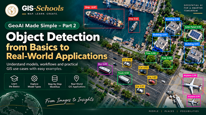
Object Detection from Basics to Real-World Applications - GeoAI Made Simple Part 2
A Beginner-Friendly Guide to Object Detection Models, Pretrained AI, Training Workflows, and GIS Applications
Imagine opening a satellite image of a city. You can see hundreds of buildings, parked vehicles, roads, trees, and other objects.
Now imagine identifying every vehicle in that image, drawing a box around it, counting the vehicles, and displaying their locations on a GIS map.
Doing this manually could take hours.
With GeoAI (Geospatial Artificial Intelligence) and object detection models, much of this work can be automated.
But how does object detection actually work? Which AI models are used? Can we use an existing model without training it? And how do we turn AI predictions into useful GIS data?
In this second part of our GeoAI Made Simple series, we will explore object detection from the basics to practical applications. You do not need an advanced background in artificial intelligence to get started.
1. What Is Object Detection in GeoAI?
Object Detection is a computer vision technique that identifies objects in images and determines where they are located.
Computer vision is a field of artificial intelligence that helps computers understand visual information such as photographs, satellite imagery, drone images, and videos.
An object detection model normally produces three important outputs:
Object Class: What has been detected, such as a car, truck, ship, or airplane.
Bounding Box: A rectangle showing where the object is located within the image.
Confidence Score: A number representing how confident the model is about its prediction.
For example, imagine an AI model analyzing an aerial photograph of a parking area. It might produce the following results:
| Detected Object | Confidence Score |
|---|---|
| Car 1 | 0.96 |
| Car 2 | 0.91 |
| Truck 1 | 0.89 |
| Car 3 | 0.84 |
These are illustrative results, not measurements from an actual model test.
The model can identify multiple objects in the same image, making it useful for automated object inventory and counting.
In GIS applications, detected object locations can also be transformed into geographic coordinates when the input imagery has reliable spatial referencing.
Important: A confidence score of 0.96 does not automatically mean there is a scientifically verified 96% probability that the prediction is correct. Model confidence must be evaluated using real test data.
2. Object Detection vs Classification vs Segmentation
Before choosing a model, it is important to understand the difference between three common GeoAI tasks.
Suppose we have a satellite image containing buildings, vehicles, trees, and roads.
| AI Task | What It Does | Example |
|---|---|---|
| Image Classification | Assigns a category to an image or image tile | Labels an image tile as a residential area |
| Object Detection | Identifies and locates individual objects | Draws boxes around vehicles |
| Semantic Segmentation | Assigns a category to each image pixel | Separates road, vegetation, and building pixels |
| Instance Segmentation | Creates a separate pixel mask for each object | Outlines each individual building |
Here is a simple way to understand the difference.
Classification asks: What is in this image?
Detection asks: What objects are here, and where are they?
Segmentation asks: Which pixels belong to each category or object?
If your goal is to count parked vehicles, object detection is often a suitable choice.
If you need the exact boundary or roof area of a building, segmentation may be more appropriate.
Remember that a bounding box is not the same as an accurate object footprint.
3. How Does Object Detection Work?
An object detection model learns visual patterns from images and uses those patterns to identify objects it has been trained to recognize.
For example, a vehicle detection model may learn characteristics such as vehicle shape, size, edges, roof appearance, and surrounding context.
The basic process can be summarized as:
Input Image → Feature Extraction → Object Prediction → Filtering → Final Detection Results
Let us understand these terms.
Input Image
The model receives an image, such as an aerial photograph showing several vehicles.
Feature Extraction
The AI analyzes visual patterns that may help distinguish vehicles from roads, buildings, shadows, or other background features.
This stage is commonly performed using neural networks. A neural network is a computer model that learns patterns by adjusting internal numerical parameters during training.
Object Prediction
The model predicts possible object locations, classes, and confidence scores.
Depending on its architecture, it may use different methods to generate these predictions.
Filtering Results
The model or its processing pipeline removes unsuitable predictions and may combine overlapping detections.
Some detectors use a technique called Non-Maximum Suppression (NMS) to reduce duplicate bounding boxes. Other modern architectures support end-to-end prediction without traditional NMS.
Final Output
The user receives an image with predicted bounding boxes, object labels, and confidence scores.
4. Types of Object Detection
Not every detection project needs the same type of bounding box or model.
Standard Object Detection
The most common approach uses rectangular boxes aligned with the horizontal and vertical axes of an image.
It is suitable for many vehicle, equipment, and general object detection applications.
Oriented Object Detection
In aerial imagery, objects are often rotated.
Ships may face different directions, vehicles may be parked diagonally, and buildings may have different orientations.
Oriented Bounding Boxes (OBB) can rotate around objects instead of remaining horizontally aligned.
This can provide a tighter representation of elongated or rotated objects.
Open-Vocabulary or Prompt-Based Detection
Traditional detectors generally recognize a fixed list of classes learned during training.
Open-vocabulary detection models can accept text prompts describing the objects to find.
For example, a user might provide the prompt:
"Solar panels on rooftops"
A compatible model then attempts to identify matching objects.
However, these predictions still need validation. A text prompt does not guarantee that the model understands every object correctly, especially in satellite or aerial imagery.
5. Popular Object Detection Model Families
Many object detection models are available today.
A model family is a group of related AI architectures. Different versions may use different network sizes, training methods, and computational requirements.
Some families focus on speed, others on detection accuracy, flexibility, or specialized tasks.
YOLO - You Only Look Once
YOLO is one of the most widely recognized object detection families.
It is popular because many of its models can identify objects quickly while maintaining useful accuracy.
The family includes multiple generations and model sizes. Modern Ultralytics implementations include YOLO26, with detection checkpoints such as YOLO26n.
YOLO26n is a relatively compact model intended for efficient inference.
Applications include vehicle detection, traffic analysis, equipment monitoring, and custom aerial imagery projects.
A small YOLO model is often a practical starting point for beginners.
Faster R-CNN
Faster R-CNN is a well-established two-stage object detection family.
It first identifies promising image regions and then performs more detailed object classification and bounding-box refinement.
Faster R-CNN is useful for research, benchmarking, and projects where accuracy requirements justify additional computational cost.
SSD - Single Shot MultiBox Detector
SSD predicts object locations and classes in a single detection pass.
It is an important earlier one-stage architecture and remains useful for understanding the development of modern detection methods.
RetinaNet
RetinaNet is another one-stage object detector.
It introduced a training approach called Focal Loss, designed to reduce the effect of the imbalance between numerous background examples and less common object examples.
RetinaNet has been used in aerial imagery analysis and other detection applications.
DETR - Detection Transformer
DETR stands for DEtection TRansformer.
Unlike conventional detection architectures, DETR introduced a Transformer-based approach that uses attention mechanisms to understand relationships across different parts of an image.
Attention helps the model learn which image features are important when making predictions.
RT-DETR - Real-Time Detection Transformer
RT-DETR combines ideas from convolutional neural networks and Transformers to achieve efficient object detection.
RT-DETR and related variants, including RT-DETRv2, are useful alternatives when comparing detector accuracy and processing speed.
For GeoAI projects, RT-DETR can be evaluated alongside YOLO and other models to determine which performs best on the target imagery.
Grounding DINO
Grounding DINO is an open-vocabulary detection model.
Rather than relying only on a predetermined class list, it accepts text descriptions and attempts to locate matching objects.
It is useful for experimentation, data exploration, and assisted annotation. Its results should be carefully checked before being used as authoritative GIS data.
Model Family Comparison
| Model Family | General Approach | Common Strength |
|---|---|---|
| YOLO | Fast, predominantly one-stage detection architectures | Efficient inference and practical deployment |
| SSD | One-stage CNN detector | Relatively straightforward baseline |
| RetinaNet | One-stage CNN detector | Handling class/background imbalance |
| Faster R-CNN | Two-stage region-based detector | Established accuracy-focused baseline |
| DETR | Transformer-based detection | Learning relationships across an image |
| RT-DETR | Efficient CNN–Transformer hybrid | Real-time-oriented Transformer detection |
| Grounding DINO | Text-guided open-vocabulary detection | Finding objects described by prompts |
Which model is the best?
There is no single best model for every GeoAI project.
A model that performs well on street-level vehicle images may struggle with small vehicles in satellite imagery.
Model selection depends on image resolution, object size, required accuracy, processing speed, hardware, and available training data.
The correct approach is to compare suitable models using the same representative test dataset.
6. What Are Pretrained Object Detection Models?
One of the biggest advantages of modern AI is that we do not always need to train a model from the beginning.
A pretrained model is a model that has already learned from an existing dataset.
For example, many general-purpose object detection models are trained on the COCO dataset, which contains 80 common object categories, including cars, buses, trucks, and boats.
You can download compatible pretrained model weights and use them to make predictions.
This process is called inference.
Inference means using a trained model to generate predictions on new images.
However, there is an important limitation.
A COCO-trained model does not automatically recognize every geospatial object.
Solar panels, electricity transmission towers, and individual tree crowns are not standard COCO object classes. Other objects may look very different from the images used during the model's original training.
Even when the class exists, a model trained mainly on ground-level photographs may not perform well on top-down satellite imagery.
This leads to three common approaches.
Approach A - Use a pretrained model directly.
This is suitable when the model already recognizes the required objects and performs adequately on your imagery.
Approach B - Fine-tune a pretrained model.
Fine-tuning means continuing training using examples from your own project.
For instance, a general object detector can be adapted using labeled aerial images showing local vehicles.
Approach C - Train a model from scratch.
This means creating a model without starting from pretrained weights.
It usually requires more training data, computational resources, and experimentation. For beginners, fine-tuning an appropriate existing model is normally the more practical starting point.
7. Where Can You Find Ready-Made Detection Models?
Several established platforms provide pretrained object detection models, model implementations, documentation, and learning resources.
| Platform | What You Can Find | Best For |
|---|---|---|
| Ultralytics | Pretrained YOLO models, training tools, inference and export support | Beginners and practical detection projects |
| Hugging Face | Detection checkpoints, Transformer-based models, model documentation | Exploring different architectures |
| ArcGIS Living Atlas | Pretrained geospatial AI packages, including detection workflows | ArcGIS users and GIS integration |
| PyTorch / TorchVision | Detection architectures, pretrained weights, training examples | Developers and researchers |
| GISSchools | Model explanations, learning resources, and selected runnable examples | Learning GeoAI concepts and workflows |
Ultralytics
Website: https://docs.ultralytics.com
Ultralytics provides pretrained YOLO detection models along with documentation for training, prediction, validation, and deployment.
Its model sizes make it possible to experiment with different speed and accuracy requirements.
Hugging Face
Website: https://huggingface.co/models
Hugging Face hosts AI model checkpoints created by different organizations and researchers.
You can filter models by tasks such as Object Detection or Zero-Shot Object Detection.
Before using a model, check its training classes, supported input format, software requirements, license, and available validation results.
ArcGIS Living Atlas
Website: https://livingatlas.arcgis.com
ArcGIS Living Atlas includes pretrained geospatial AI models that can be used in supported ArcGIS workflows.
Examples include detection packages and Grounding DINO-based workflows.
ArcGIS also provides an HF Object Detection deep learning package that can connect compatible Hugging Face object detectors with ArcGIS.
Model packages commonly use the .dlpk (Deep Learning Package) format.
Depending on the model and environment, detection workflows can run through ArcGIS Pro, ArcGIS Enterprise, or supported ArcGIS Online imagery capabilities.
Check the model documentation and applicable ArcGIS licensing requirements before deployment.
PyTorch / TorchVision
Website: https://pytorch.org/vision/
TorchVision provides pretrained detection architectures and training examples, including region-based models.
It is particularly useful for developers who want more control over model training and experimentation.
GISSchools GeoAI Model Library
Website: https://gisschools.com/geoai.php
The GISSchools GeoAI Model Library organizes learning materials by task categories.
Under Detection, you can explore resources such as:
YOLO26n – COCO Object Detection: A compact pretrained detector for common object categories.
RT-DETR R18vd – COCO Object Detection: A Transformer-based detection model suitable for learning and experimentation.
Synthetic Object Detector – Learning Demo: An educational example based on synthetic data. It demonstrates detection concepts but is not evidence of performance on real-world imagery.
Visit the GISSchools Detection Model Library to explore these models in more detail.
Remember that a learning demo, an official pretrained checkpoint, and a production-ready geospatial model represent different levels of maturity and validation.
8. What Makes Object Detection Different in GeoAI?
A normal object detection model works with image pixels.
GeoAI adds geographic information, which introduces several additional challenges.
Image Resolution
The first important factor is image resolution.
In remote sensing, we commonly use Ground Sampling Distance (GSD) to describe how much ground area a pixel represents.
For example, an image with 20 cm GSD represents approximately 20 cm on the ground per pixel.
Consider a car that is four metres long.
At 20 cm GSD, its length would cover approximately 20 pixels.
At 50 cm GSD, the same car would cover approximately 8 pixels.
A smaller visual representation generally makes object recognition more difficult.
This is why the highest-quality AI architecture cannot compensate for objects that are too small or unclear in the source imagery.
Object Size and Orientation
Satellite images contain objects of very different sizes.
A commercial building may cover thousands of pixels, while a small vehicle may occupy only a handful.
Objects also appear at different angles, which can make oriented detection useful.
Geographic Coordinates
A normal image detector identifies objects using pixel positions.
For GIS applications, we often need the corresponding map coordinates.
If the image is correctly georeferenced, its spatial transformation can be used to convert pixel locations into map coordinates.
Large Image Sizes
A satellite image or orthomosaic may contain hundreds of millions of pixels.
Processing the entire image at once may exceed a model's input size or available GPU memory.
A common solution is to divide the image into smaller sections called tiles or image chips.
Overlapping tiles can help detect objects close to tile boundaries.
However, overlapping predictions must be merged carefully to avoid counting an object more than once.
Tools such as SAHI (Slicing Aided Hyper Inference) support sliced detection workflows for large images.
Different Sensors and Image Types
Satellite, drone, and aerial images can differ in resolution, viewing angle, lighting, and spectral bands.
A model trained on ordinary three-band RGB images may not directly accept additional multispectral bands.
The input channels and preprocessing must match the model's requirements, or the model must be adapted appropriately.
9. Preparing a Dataset for Object Detection
If a pretrained model does not perform adequately, you may need to train or fine-tune it.
Training requires examples showing what the model should learn.
For object detection, these examples usually include images and annotations.
An annotation identifies the location and class of an object in an image.
For example, a vehicle annotation includes a bounding box and a label such as "car."
Common detection dataset formats include YOLO annotations and COCO JSON.
The formats store information differently, so annotations must match the format expected by the selected training framework.
What Makes a Good Dataset?
A useful dataset should represent the actual environments where the model will operate.
For a vehicle detector, this may include different vehicle sizes, colours, parking arrangements, road surfaces, shadows, and viewing conditions.
Correct labels are essential.
If some vehicles are missing from annotations, or buildings are incorrectly labeled as vehicles, the model may learn unreliable patterns.
It is also important to include representative images where the target object is absent, so the model can learn background conditions.
Training, Validation, and Testing
A dataset is commonly divided into three groups.
Training Data: Used by the model to learn.
Validation Data: Used to monitor performance and help select training settings.
Testing Data: Kept separate for independent evaluation after model development.
In GeoAI, randomly dividing neighboring image tiles can produce misleading results because nearby tiles may contain nearly identical roads, buildings, and landscapes.
A better practice is to separate training and testing by geographic areas, scenes, or acquisition groups where appropriate.
10. Complete A-to-Z Object Detection Workflow
Now that we understand the fundamentals, let us connect everything into a practical GeoAI workflow.
Suppose a municipality wants to identify and count vehicles from aerial imagery.
The complete process could look like this.
Step 1 - Define the Problem
Decide exactly what the model should detect.
In this example, the objective is to locate vehicles and create a geographic inventory.
Define the classes, such as car, bus, and truck, along with the required output and acceptable error levels.
Step 2 - Collect Suitable Imagery
Obtain satellite, drone, or aerial imagery of the study area.
Check that the imagery has sufficient resolution, acceptable visual quality, and the required geographic coverage.
Confirm that its use is permitted under the relevant data license.
Step 3 - Check Spatial Information
Verify the image's Coordinate Reference System (CRS), geographic extent, pixel size, and spatial alignment.
A CRS defines how geographic positions are represented in a map.
Ensure that the image is properly georeferenced before planning geographic outputs.
Step 4 - Prepare Image Tiles
Divide large images into smaller tiles suitable for the selected model.
Use an appropriate tile size and, when needed, overlap between adjacent tiles.
Preserve each tile's location relative to the original image so that predictions can later be mapped correctly.
Step 5 - Prepare and Label Training Data
If custom training is required, identify representative vehicles in the imagery and draw accurate bounding boxes.
Assign correct class labels.
Review annotations and correct errors before training.
Step 6 - Divide the Dataset
Create separate training, validation, and testing datasets.
Avoid placing near-duplicate imagery from the same area into both training and testing groups.
Step 7 - Select a Model
Start with a suitable pretrained model.
YOLO or RT-DETR may be reasonable baselines for vehicle detection.
If objects are strongly rotated, evaluate an oriented bounding-box detector as well.
Compare models using your own data rather than relying only on published benchmark rankings.
Step 8 - Train or Fine-Tune
Run training using the labeled dataset when direct pretrained inference is insufficient.
The model gradually adjusts its parameters to improve its predictions.
You may also use data augmentation, which creates controlled variations of training images through methods such as rotation, flipping, brightness changes, or scaling.
Augmentations must remain realistic for the task and preserve correct labels.
Step 9 - Evaluate the Model
Test predictions against accurately labeled reference objects.
Measure false detections, missed objects, and localization quality.
Review results across different geographic areas and image conditions.
Do not move to production simply because the model performs well on a few attractive example images.
Step 10 - Run Detection on New Imagery
Use the selected trained model to detect objects in new images.
For large orthomosaics, perform tile-based inference where necessary.
Merge overlapping tile results and resolve duplicate detections.
Step 11 - Convert Results into GIS Features
Transform the predicted pixel coordinates into geographic coordinates using the original image's georeferencing information.
Create GIS features such as bounding-box polygons or object-centre points.
Store useful attributes, including object class, confidence score, acquisition date, and model version.
Step 12 - Validate, Publish, and Maintain
Review the results in QGIS, ArcGIS, or another GIS application.
Check their positional accuracy, count accuracy, and completeness against representative ground truth.
After approval, publish the resulting GIS layers to the required database, map service, or dashboard.
Monitor model performance when new imagery is introduced, and update the model when necessary.
This workflow can be adapted to many different detection applications. The exact tools may change, but the fundamental steps remain similar.
11. How Do We Measure Detection Accuracy?
A model that draws hundreds of boxes is not necessarily a good detector.
We need to know whether those boxes identify real objects and whether the correct objects have been missed.
Several important evaluation metrics help us understand model performance.
| Metric | Simple Meaning |
|---|---|
| Precision | Of all reported detections, how many were correct? |
| Recall | Of all real objects, how many did the model find? |
| IoU | How closely does the predicted bounding box overlap the correct box? |
| AP | Average Precision, summarizing precision–recall performance for a class under an evaluation protocol |
| mAP | Mean Average Precision across classes, sometimes also across multiple IoU thresholds |
| Inference Time | How long the model takes to process an image or batch |
Precision
Precision is particularly important when false detections are expensive.
For example, if a model identifies road markings as vehicles, its reported vehicle count becomes unreliable.
Recall
Recall is important when missing real objects is a serious problem.
A vehicle inventory system should not overlook a large proportion of vehicles simply because the model uses a strict confidence threshold.
Intersection over Union (IoU)
IoU measures the overlap between a predicted bounding box and the correct bounding box.
It ranges from 0 to 1.
A higher IoU generally indicates better localization.
Mean Average Precision (mAP)
mAP combines detection quality across object classes.
You may see metrics such as mAP@0.50 or mAP@0.50:0.95 in model documentation.
The first uses an IoU threshold of 0.50. The second summarizes results over several IoU thresholds from 0.50 to 0.95.
These values are useful for comparison when models are evaluated using the same dataset and evaluation settings.
For real-world GeoAI, model accuracy should also be assessed against the business goal.
For example, a parking analysis project may require reliable vehicle counts rather than just attractive bounding boxes.
12. How Do We Convert Detection Results into GIS Data?
This is one of the most important differences between general computer vision and practical GeoAI.
A detector often produces image coordinates such as the top-left and bottom-right corners of a bounding box.
These coordinates are measured in pixels, not latitude and longitude.
If the source imagery is georeferenced, those pixel positions can be converted into geographic map coordinates.
For example, after detecting vehicles from an orthomosaic, we can create a vector layer containing one feature for each vehicle.
The GIS output might contain the following fields:
| Attribute | Description |
|---|---|
| Object_ID | Unique identifier for the detection |
| Class_Name | Car, bus, truck, or another class |
| Confidence | Model confidence score |
| Geometry | Bounding-box polygon or object-centre point |
| Image_Date | Date of the source imagery |
| Model_Version | Model checkpoint or version used |
| Review_Status | Whether the detection was manually verified |
The output can be stored in formats such as GeoJSON, GeoPackage, or an ArcGIS feature class.
For larger systems, the results can be stored in a spatial database such as PostGIS.
What Can We Do with These GIS Layers?
Once detections become geographic features, they can be combined with other GIS datasets.
For example, vehicle locations can be spatially joined to parking zones, buildings, road segments, or administrative boundaries.
The results can then be used to generate counts, identify patterns, support field verification, or create monitoring dashboards.
However, GIS integration requires more than attaching a coordinate to an AI prediction.
The original image must have reliable geographic referencing, and coordinate transformation errors must be checked.
An ordinary unreferenced photograph cannot automatically provide accurate geographic object locations.
Also, bounding-box polygons should not be presented as accurately digitized object boundaries.
13. Real-World Applications of Object Detection in GeoAI
Object detection has many practical applications across urban planning, infrastructure, transportation, environmental monitoring, and asset management.
Vehicle Detection
Aerial or drone images can be used to detect cars, trucks, buses, or other vehicles.
Potential applications include parking occupancy estimates, traffic-related studies, and vehicle inventories.
Vehicle counting requires special attention to image resolution, occlusion, and duplicate detections.
Building Detection
Detection models can identify approximate building locations and count individual structures.
This may support urban inventory creation or help prioritize manual mapping.
If accurate building footprints or roof-area measurements are required, segmentation or conventional GIS digitization may be more suitable.
Solar Panel Detection
Models can identify rooftop solar panels or larger solar installations when imagery quality is sufficient.
Such workflows can support renewable energy inventories, site monitoring, and installation surveys.
General COCO-trained detection models should not be assumed to recognize solar panels without suitable training, prompting, or fine-tuning.
Ship Detection
Satellite and aerial imagery can support detection of vessels in harbors, ports, and coastal areas.
Oriented bounding boxes can be especially useful because vessels often appear at different angles.
Agricultural and Environmental Monitoring
Object detection can be applied to visually distinct agricultural assets, individual trees, or selected field features.
However, tree canopy mapping and vegetation area measurement may require segmentation instead of standard object detection.
Infrastructure and Asset Monitoring
Specialized detection models may help locate infrastructure components, equipment, or visible assets in sufficiently detailed inspection imagery.
The choice of imagery and model must reflect the physical size and visibility of each target.
14. A Practical Example: Detecting Cars from Drone Imagery
Let us consider a simple learning project.
A local authority wants to estimate the number of cars in a parking area using drone imagery.
The first requirement is a clear, georeferenced image with enough detail to distinguish individual vehicles.
We could initially test a pretrained YOLO detection model on several representative image tiles.
If it identifies cars reliably, we may use the pretrained model without additional training.
If it misses many vehicles or confuses cars with other objects, we can prepare a labeled aerial vehicle dataset and fine-tune the model.
We would then evaluate the result using separate test imagery.
After detection, the predicted bounding boxes would be transformed into map coordinates and stored as GIS features.
Using QGIS or ArcGIS, we could compare the detected vehicles with mapped parking areas and calculate counts for individual zones.
The final result would not just be an image with boxes.
It would be a spatial dataset that can support mapping, analysis, and reporting.
That is where object detection becomes useful GeoAI.
15. Common Mistakes Beginners Should Avoid
Choosing the model before defining the problem. A fast model is not useful if it produces the wrong type of output.
Using imagery with insufficient detail. Tiny objects cannot be detected reliably when they are not visually distinguishable.
Assuming pretrained models understand every object. Training classes and image domains matter.
Using poor annotations. Incorrect labels can reduce model quality even when the network architecture is advanced.
Testing on imagery that is nearly identical to training data. This can produce unrealistic accuracy estimates.
Ignoring false positives and missed objects. A visually convincing result may still produce incorrect inventories.
Confusing detection boxes with accurate feature boundaries. Bounding boxes are useful for localization, but not automatically for measuring the actual shape or area of an object.
Ignoring model licensing and deployment requirements. A downloadable model is not necessarily approved for every commercial or production use.
Publishing results without geographic quality checks. A correct detection with incorrect map coordinates can still create misleading GIS information.
The most successful projects do not depend only on choosing a powerful model. They combine suitable imagery, accurate training data, sensible evaluation, geographic processing, and quality control.
16. Where Should Beginners Start?
If you are just beginning your GeoAI journey, start with a small and clearly defined detection task.
For example, try identifying cars in a sample aerial image using an existing pretrained detector.
Understand what bounding boxes, labels, and confidence scores represent.
Next, compare the model's predictions with the actual objects in the image.
Once you understand inference, explore dataset annotation and fine-tuning.
Finally, learn how to convert detections into GIS features and visualize them on a map.
You do not need to learn every detection architecture before starting a practical project.
Learn one task, test one model, understand its limitations, and then move to the next level.
17. Continue Learning with GISSchools
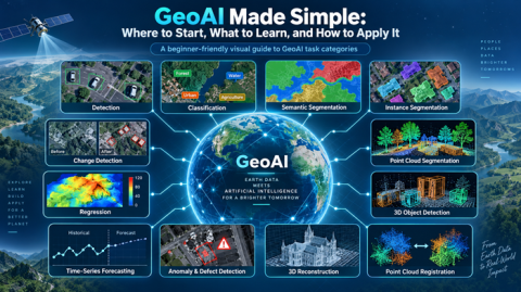
GeoAI includes many other tasks beyond object detection, including image classification, semantic segmentation, instance segmentation, change detection, point cloud segmentation, and 3D object detection.
Each serves a different purpose, and each requires its own approach to data preparation and evaluation.
To understand the complete learning roadmap, read our first article:
GeoAI Made Simple: Where to Start, What to Learn, and How to Apply It
To learn about individual AI architectures and explore their model resources, visit:
GISSchools – GeoAI Model Library
The library provides explanations and resources organized by AI task, helping learners connect theoretical concepts with practical model experimentation.
Final Thoughts
Object detection is one of the most accessible ways to begin learning GeoAI.
It connects the power of artificial intelligence with imagery, geographic coordinates, and spatial analysis.
However, the real goal is not simply to draw boxes around objects.
The goal is to turn visual information into reliable geographic knowledge that supports better decisions.
A successful GeoAI project begins with the right question, uses suitable data, selects an appropriate model, evaluates the results, and produces useful GIS information.
GeoAI is not about using the most complicated model. It is about solving the right geographic problem with the right technology.
Official References and Further Reading
The following technical resources provide additional guidance on detection architectures, model training, evaluation, and GIS integration.
Ultralytics: Object Detection Documentation — Pretrained models, inference, training, evaluation, and model export.
Ultralytics: Oriented Bounding Box Detection — Rotated object detection for applications such as aerial imagery.
Hugging Face: Object Detection Guide — Transformer-based object detection and fine-tuning.
Esri: ArcGIS Pretrained AI Models — Geospatial AI model resources and application guidance.
Esri: HF Object Detection for ArcGIS — Using compatible Hugging Face object detection models in ArcGIS.
PyTorch: TorchVision Object Detection Fine-Tuning — Training and adapting pretrained detection models.
GISSchools: GeoAI Learning and Model Library — Task-based model explanations and educational resources.
Published as part of the GISSchools GeoAI Made Simple learning series.

Comments
No comments yet. Start the discussion.
Leave a reply
Your email address will not be published. Required fields are marked.